WESTERN PRODUCER — It was an interesting month across the Prairies when it came to weather in January.
Looking at the data, we can see that Alberta had a really warm January with all three stations not only reporting the highest actual temperatures, but also the largest difference from average.
Peace River came in at a remarkable 6.5 degrees above average. We must go all the way back to 2012 to find a January anywhere across the Prairies that was that much above average.
The coldest readings, both in actual and compared to average, were found in southern Saskatchewan and Manitoba.
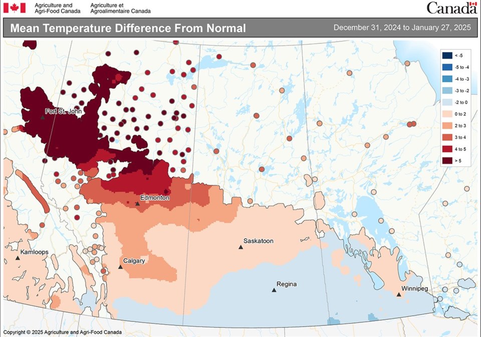
Warm January for Alberta – This map shows the mean temperature deviation from average. You can see Alberta had a very warm January with all three stations not only reporting the highest actual temperatures, but also the largest difference from average. Peace River came in at a remarkable 6.5 degrees above average. | Source: Environment Canada, Agriculture Canada
January is one of the driest months of the year, so while all regions or locations reported below average precipitation in the month, the overall amounts were not too bad.
The “wet” spots were southern and central Alberta along with Dauphin in Manitoba. The “dry” spots were Winnipeg and Peace River.
Here are the latest three-month outlooks.
The Old Farmer’s Almanac calls for a cold and snowy February and March, followed by a warm April with near average precipitation.
The Canadian Farmers Almanac is calling for February to be a stormy month, which would indicate above average precipitation. They only mention cold weather once, so I will go with near average temperatures. March is calling for near average for both temperatures and precipitation. Looking at April, it sounds like near average temperatures and above average precipitation.
When we look at the National Oceanic and Atmospheric Administration (NOAA) weather model and extrapolate northward, it appears to be calling for below average temperatures with above average precipitation over the western Prairies and near average amounts over central and eastern regions.
Next is the CFS model, which is calling for a very cold February across Alberta and Saskatchewan with near to slightly below average temperatures in Manitoba.
This same pattern is forecasted to continue into March and April but with the anomalies warming to only slightly below average in Alberta by April with Manitoba seeing slightly above average temperatures.
Precipitation is predicted to be near to above average for all three months.
Moving on to last month’s winner, the CanSIPS model is calling for slightly above average temperatures and precipitation over the eastern Prairies, near average temperatures and precipitation over the central Prairies, and slightly below average temperatures and near average precipitation over far western regions.
Finally, our last weather model, the European, or ECMWF, is predicting below average temperatures in February across Saskatchewan and Alberta with near average temperatures in Manitoba.
March is looking to see near average temperatures with April coming in near to slightly above average.
Their precipitation prediction is for above average amounts over Alberta in February with near average amounts in Saskatchewan and Manitoba. March and April are predicted to see near average amounts right across the Prairies.
Last and definitely least is my throw at the weather dart board. Just like last month, I am still leaning toward the European model, which is similar to the CFS model.
Daniel Bezte is a teacher by profession with a BA in geography, specializing in climatology, from the University of Winnipeg. He operates a computerized weather station near Birds Hill Park, Man. Contact him at [email protected].
About the author
Related Coverage
Record heat and moisture seen globally in 2024
A look back at weather across the Prairies in 2024
Cold and snow seen for winter’s second half
The many weather stories of 2024
More advice offered on buying a weather station


