The design for a green on brown weed locator is now available to anyone who wants to build their own site-specific weed management tool.
The OpenWeedLocator (OWL) is an open-source, low-cost image-based approach for fallow weed detection.
Guy Coleman from the University of Sydney, Australia, is working on the project. He said the OWL is an opportunity to redefine the approach to weed detection, by enabling community-driven technology development and implementation.
“It’s a box that has a camera, a Raspberry Pi and a set of relay control boards. Because we published all the open-source information about how it works, anyone can contribute and develop and build one of these,” Coleman said.
He said the OWL is an improvement on weed detection systems that use reflectance-based sensors because this system uses cameras and image analysis to locate weeds.
“Using cheaper cameras and control boards really shifts things to detection and image analysis to get an actionable output, where you can plug in a spray solenoid to one of the relay boards, or use it to control a targeted tillage tool.”
For instance, a product called the Weed Chipper is used in Australia uses specifically-designed rapid response tines that drop down and till individual weeds.
“If you want to make a spot sprayer, you just have to set up the nozzle controls so each nozzle can turn on or off independently.”
Everything in the modular OWL box requires a 12-volt power source.
The OWL has not been designed to connect to nozzle control systems on existing sprayers. Instead, it is the control system for homemade selective weed management tools.
So far, the OWL works at speeds up to eight kilometres per hour.
Coleman said the OWL can be used with sprayers mounted on the back of trucks, on a UTV, and there is research being done with an autonomous platform that uses the OWL.
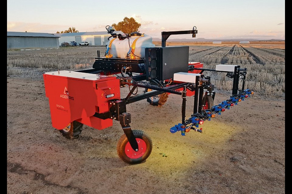
The system is installed on a Agerris Digital Farmhand robot for two-metre wide spot spraying at the University of Sydney Plant Breeding Institute in Narrabri, Australia.
The OWL can be used with any small robotic platform to run the detection and application side of homemade site-specific weed management tools.
Open source encourages user feedback
“We went down the open-source path because of the benefits of having that end-user experience feeding back into development,” Coleman said.
“Another main driver for us was to help develop a community around weed detection and site-specific weed control. That would then move this not just where we detect in fallow situations, so green on brown. But also into more complex scenarios like in-crop applications, because it’s all image based,” Coleman said.
He said an inspiration for making the OWL open source is Brian Tishler who farms near Mannville, Alta., and is the driving force behind Ag Open GPS, an open-source mapping, guidance and section control software.
“He (Tishler) developed a community with people around the world who contribute to the software and designs, who tell their stories of what they built and how they took the initial ideas and changed them slightly to improve it and their contribution can help everyone else,” Coleman said
Tishler said green on brown spot spraying platform has a limited-use case in Canada because few people chemical fallow on the Prairies, but there are many growing areas around the world that will benefit from this system.
“The next step of what Guy’s (Coleman) working on, and of course others are working on as well, including people in the Ag Open GPS Community. They’re doing a lot of computer vision stuff, that’s kind of the direction I’m heading as well,” Tishler said.
“We don’t need to identify the weed. We only need to identify the crop and remove everything else. I think there’s huge potential there.”
There are multiple companies that use computer vision and artificial intelligence-based systems to identify weeds in real time and so that weeds can be identified and managed without operator interventions.
This is painstaking work that requires training algorithms to recognize weeds and crop, by taking thousands of images of weeds and then categorizing the weeds, and even the pixels in the images that contain the weeds.
Most algorithms capable of weed differentiation are being developed by companies and are proprietary.
However, both Ag Open GPS and the OWL are reaching out for user participation to help identify and categorize weeds, and the resulting algorithms will be available for anyone to use and improve.
The computing power and control systems for individual weed management are already available. The biggest obstacle for these systems is a repository of weed and crop images equipment manufacturers or developers can have access to.
Tischler said there is room for the government, producer groups or universities to get together to help build an open database for weed identification that developers could use to build site specific weed management tools.
“Canada could be an absolute shining star in terms of getting a repository together and getting a home to begin to accumulate this data,” Tishler said.
“Could you imagine if the University of Saskatchewan started this project where they said, ‘OK, we’re going to follow the Ag Open GPS model where we’re going to involve farmers worldwide to send in these pictures.’ What a feather in the hat for any country or province that does that.”


