SASKATCHEWAN — Update June 28, 3:30 p.m.: The Water Security Agency is advising the public of increased flows on smaller rivers and creeks. This is a result of the significant weather system last night which will continue to bring heavy rain to Saskatchewan, says the WSA.
Weather models indicate the system will impact the west central portion of Saskatchewan before tapering off as it moves towards the southeast. With large amounts of moisture in a short amount of time, it may result in increased runoff and flows in rivers, streams and lakes across Saskatchewan, which can cause localized out-of-channel flows and localized flooding. Major river systems will remain unaffected by this event. In addition, some water and sewer systems may be overwhelmed causing overflows or bypasses.
Overnight approximately 70 mm of precipitation was observed around Rosetown and Hanna, Alta., both of which contribute to the South Saskatchewan River System. The remainder of central Saskatchewan received significant rainfall ranging between 14-50mm.
Forecasts for the next three days indicate that central and west central Saskatchewan may receive up to 75 mm of precipitation while the southern portion of the province is expected to receive less but significant amounts ranging from 10-40 mm. Localized thunderstorms could potentially produce 100mm or more.
Update June 28 11:45 a.m.: All rainfall warnings have ended.
Southeast Saskatchewan, however, is under a tornado watch.
Update June 28 8:45 a.m.: Environment Canada says the rain should be tapering off later today.
As of Friday morning, general rainfall amounts have been 40 to 60 mm, with some heavier pockets resulting in amounts in excess of 80 mm. Although the heaviest rain has passed, rain will continue this morning before tapering off this afternoon, says the agency.
Strong easterly winds will also accompany the rain, with gusts to 70 km/h expected late today.
Conditions will improve as the system pulls out of the area tonight.
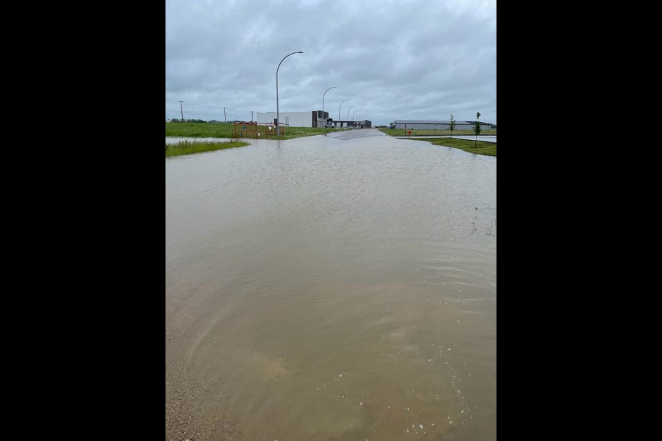
Localized flooding in low-lying areas is possible. Heavy rainfall in combination with other weather factors, such as hail, wind and lightning will make outdoor activities unsafe.
Watch for possible washouts near rivers, creeks and culverts.
There are no funnel cloud alerts today.
Original post June 27: The Water Security Agency is advising the public of a significant weather system likely to bring heavy rain and increased flow to Saskatchewan.
Heavier rain is forecast for areas around Kindersley, North Battleford, Biggar, Outlook, Saskatoon, Rosthern, Humboldt, Foam Lake, Regina Beach, Buffalo Pound Lake, Davidson, as well as the north end of Lake Diefenbaker, including Riverhurst and Elbow.
Environment Canada has issued rainfall warnings for a number of locations within the blue portion of the map accompanying this story. Meanwhile, the southwest corner of the province is under a weather statement indicating funnel clouds are possible.
The rainfall is also expected to impact the headwaters of the North and South Saskatchewan rivers in Alberta. As much as 50 to 75mm of rain is expected with this system, and localized thunderstorms could potentially produce 100mm or more.
This large amount of moisture is expected to fall in a short amount of time, resulting in increased runoff and flows in rivers, streams and lakes across Saskatchewan, which can cause localized out-of-channel flows and localized flooding. WSA will be monitoring the situation closely throughout the weekend.
As for the funnel clouds, Environment Canada says these types of funnel clouds are generated by weak rotation under rapidly growing clouds or weak thunderstorms. This weak rotation is normally not a danger near the ground. However, there is a chance that this rotation could intensify and become a weak landspout tornado.
Landspout tornadoes do not usually cause significant damage but can still be dangerous. They can be strong enough to topple trees, damage roofs or toss debris short distances.
Treat any funnel cloud sighting seriously, warns Environment Canada. Should a funnel cloud develop nearby, prepare to take shelter. These funnel clouds usually appear with little or no warning.
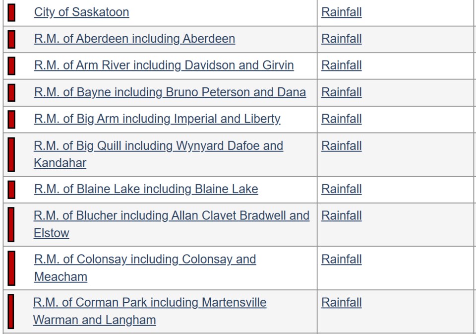
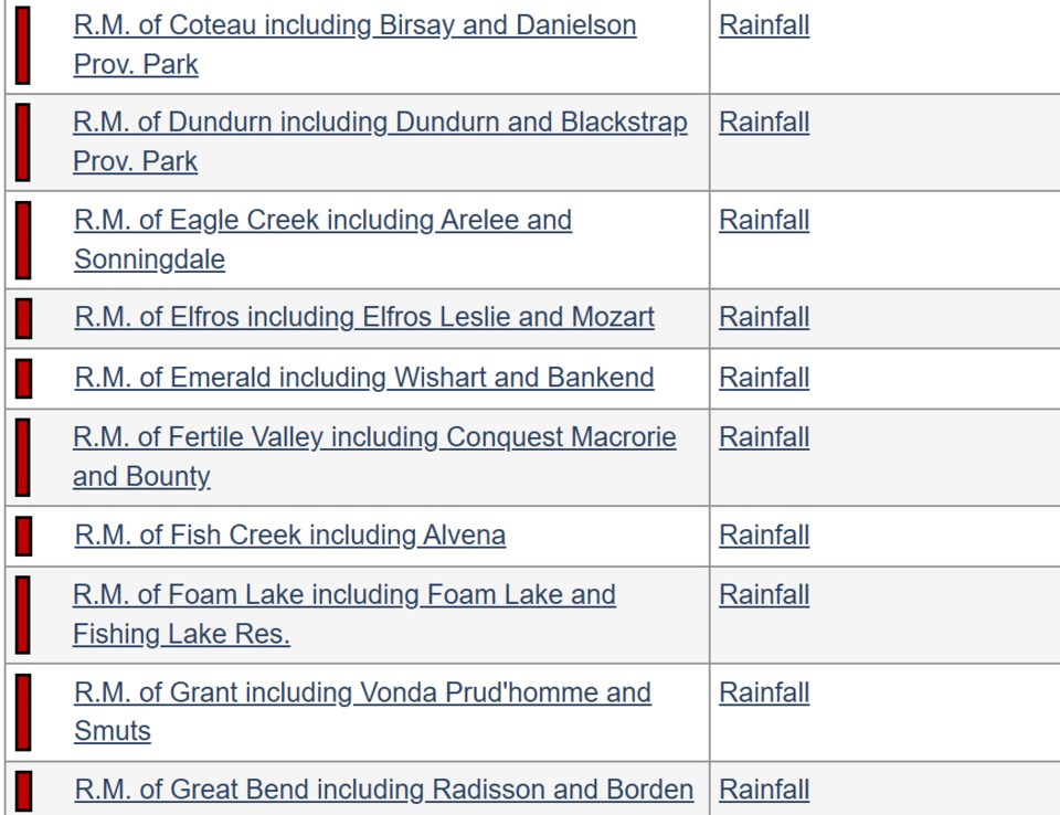
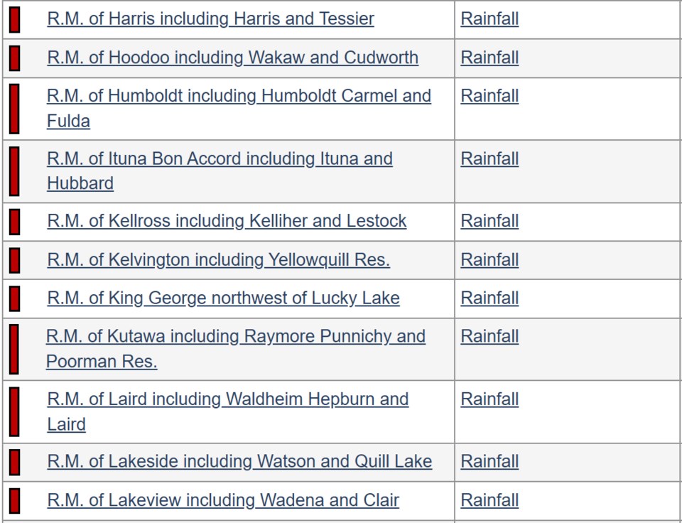
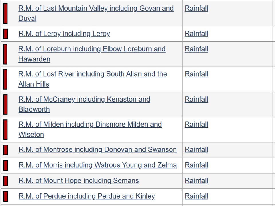
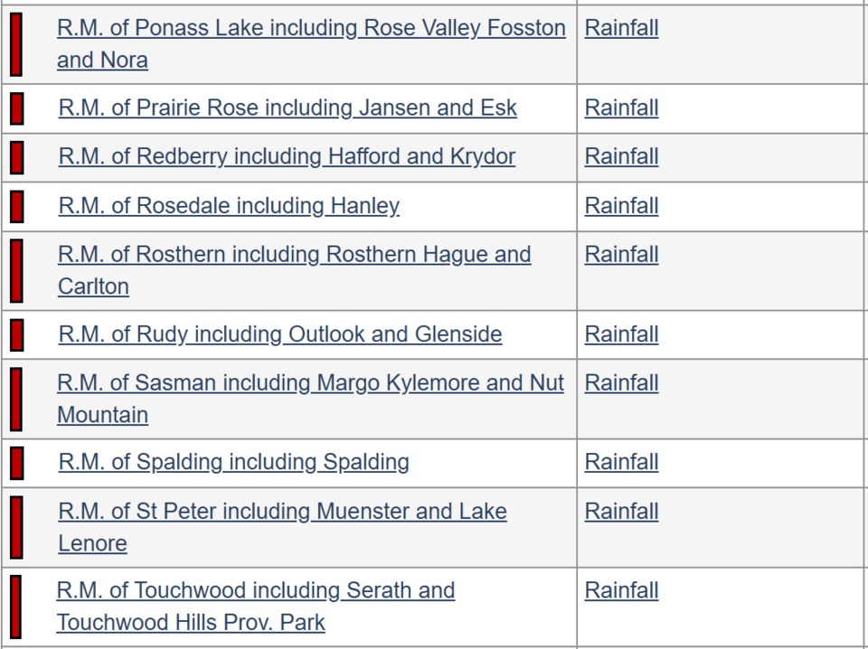
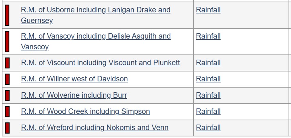
Communities under a rainfall warning as of 8:45 a.m. Friday:
Update: as of 10 a.m.warnings ended for Humboldt, Saskatoon Martensville.